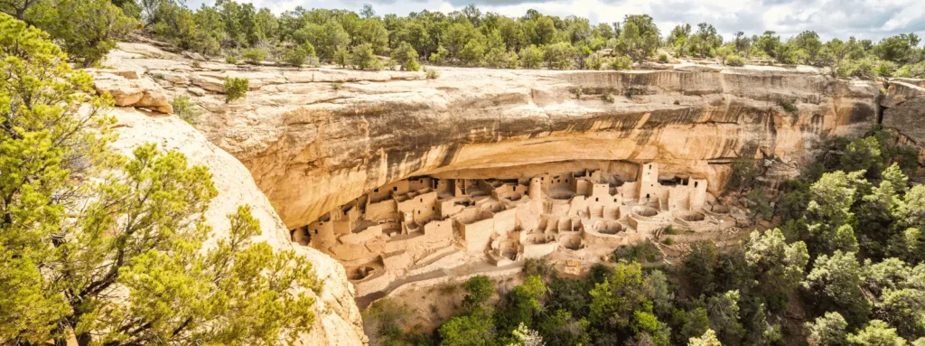
Mesa Verde National Park offers more than a glimpse into ancient cliff dwellings. For visitors who enjoy the outdoors, nearly 30 miles of hiking trails provide a chance to experience the same landscapes once walked by the Ancestral Puebloan people. These routes lead through pinyon-juniper forests, rugged canyons, and sweeping mesa-top vistas, offering a different perspective of the park’s history and ecology. This guide to Mesa Verde hiking trails and nature walks highlights the park’s best overlooks, trail conditions, and planning tips. It also explains why staying just seven miles away at Mesa Verde Motel in Mancos, Colorado, makes an ideal home base for exploring the park’s trails.
Why Hike Beyond the Ruins?
While most visitors come to see Mesa Verde’s cliff dwellings, hiking the park’s nature trails reveals a broader story. These routes traverse sloping mesas, canyons, and forests shaped by centuries of natural and human history. Hikers find scenic overlooks with views stretching across the Montezuma and Mancos valleys to the distant San Juan Mountains.
The park’s landscapes are diverse. Pinyon-juniper forests shade mesa tops, while rugged canyon floors host a surprising variety of plant and animal life. Hiking Mesa Verde beyond the ruins allows visitors to experience the region’s ecosystems and see how the Ancestral Puebloan people adapted to these challenging environments.
Takeaway: Hiking in Mesa Verde National Park connects the cultural past with its natural beauty.
Planning Your Hike: Conditions, Difficulty, and Safety
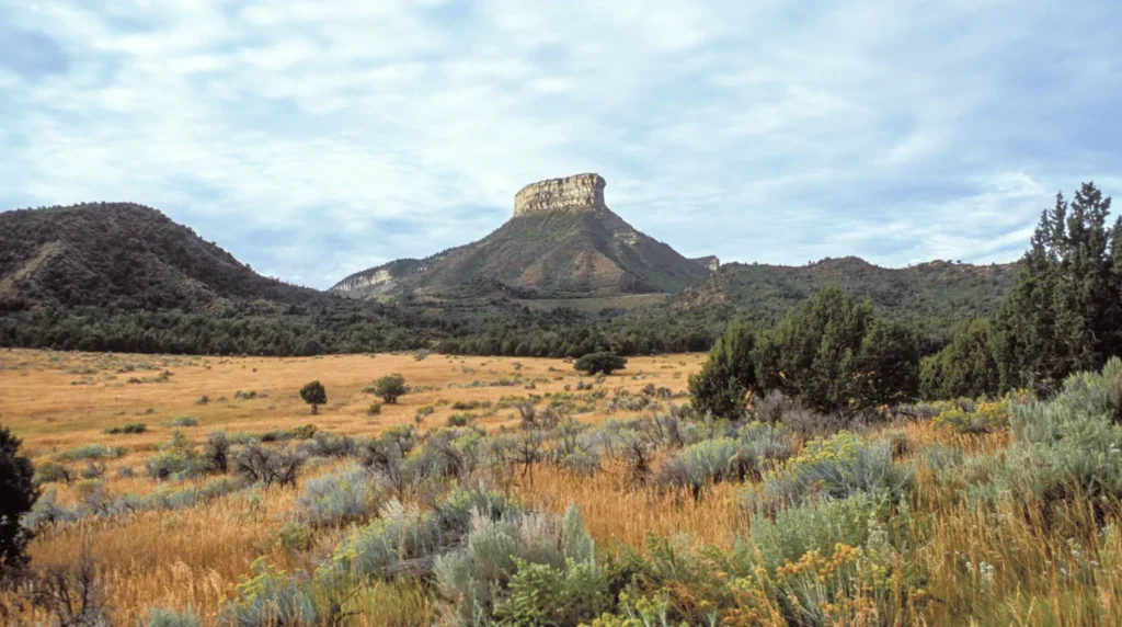
At over 7,000 feet in elevation, Mesa Verde’s thin air and steep terrain can challenge even experienced hikers. Acclimatization, hydration, and pacing are key to enjoying the park’s trails.
- Trail difficulty: Most trails, except for Soda Canyon, are rated moderate to strenuous due to elevation gain and rocky surfaces. Good hiking shoes are essential.
- Seasonal access: Wetherill Mesa trails are open only from late May through early September, with gate hours from 8:30 a.m. to 4 p.m. and closures on Tuesdays and Wednesdays. Trails in other areas may be muddy or slippery in winter after summer rains.
- Trail etiquette: Hikers are asked to stay on marked paths to protect fragile archaeological sites and native plants. Pets are restricted to specific trails on Wetherill Mesa and the Mesa Top Loop Drive.
Safety tips:
- Carry and drink plenty of water.
- Wear sturdy footwear and sun protection.
- Watch for altitude sickness symptoms such as dizziness or shortness of breath.
- Check current conditions with park staff before starting longer routes.
Takeaway: Planning ahead ensures a safe and enjoyable experience across Mesa Verde’s varied trail systems.
Must-See Nature Hikes and Overlook Trails
Mesa Verde’s trail network is grouped into three main areas: Morefield Canyon, Chapin Mesa, and Wetherill Mesa. Each offers unique views and levels of difficulty.
Morefield Canyon Area
Trailhead: Morefield Campground
- Point Lookout Trail: A 2.2-mile round-trip climb of 400 feet to a mesa-top ridge overlooking the Montezuma and Mancos valleys. This moderate hike rewards visitors with panoramic views of the San Juan and La Plata mountains.
- Knife Edge Trail: A 2-mile out-and-back route following a section of the original 1914 park road. The mostly level path traces the north escarpment and provides excellent sunset views.
- Prater Ridge Trail: The park’s longest and most strenuous loop, at 7.8 miles round-trip with 675 feet of elevation gain. The ridge-top vistas extend across canyons and valleys, offering a full-day challenge.
Chapin Mesa Area
Trailhead: Spruce Tree House Overlook and Chapin Mesa Museum
- Petroglyph Point Trail: A rugged 2.4-mile loop with steep climbs, narrow passages, and a 227-foot elevation change. The trail features a large petroglyph panel and returns through pinyon-juniper forest.
- Spruce Canyon Trail: This 2.4-mile route descends into the canyon beneath Spruce Tree House, passing through shaded areas and then climbing back to the mesa top.
- Soda Canyon Overlook Trail: A short, easy trail offering views of cliff dwellings and canyon walls. Suitable for beginners and families.
- Farming Terrace Trail: A half-mile path that descends into a canyon drainage, passing ancient check dams built by the Ancestral Puebloan people.
- Far View Sites Trail: A 0.75-mile loop that connects several ancient mesa-top villages, including Far View House and other excavated structures.
Wetherill Mesa Area
Trailhead: Wetherill Mesa Kiosk (seasonal access)
- Step House Trail: A 1-mile loop descending 165 feet into Long Canyon. Visitors can see two distinct periods of Pueblo architecture. The trail is open only when rangers are present.
- Long House Loop: A 5-mile paved trail open to pedestrians, cyclists, and leashed pets. It connects several overlooks, including Badger House Community and Kodak House Overlook.
- Badger House Community Trail: A 2.25-mile loop through four excavated mesa-top villages representing six centuries of Pueblo history.
- Nordenskiöld Site #16 Trail: A 2-mile trail leading to an overlook of a large 50-room cliff dwelling in Rock Canyon.
Takeaway: Each trail offers a window into Mesa Verde’s landscapes, from canyon floors to mesa-top villages.
Suggested Itineraries and Trail Combinations
To make the most of a visit, hikers can plan half-day or full-day routes that match their ability level and schedule.
- Half-Day Easy Routes:
- Knife Edge Trail for sunset views
- Soda Canyon Overlook, combined with the Far View Sites Trail
- Half-Day Moderate Route: Point Lookout Trail paired with Farming Terrace Trail
- Full-Day Adventures:
- Wetherill Mesa exploration with Step House, Long House Loop, and Badger House Community (seasonal)
- Canyon routes like Petroglyph Point or Spruce Canyon for challenging terrain
- Multi-Day Itinerary: Spend one day exploring Morefield Canyon, another on Chapin Mesa, and a third on Wetherill Mesa when open.
Takeaway: Combining short and long trails creates a balanced itinerary that showcases Mesa Verde’s natural and cultural variety.
Tips for Making the Most of Your Hike
Mesa Verde’s high elevation and open terrain mean preparation matters.
- Best times to hike: Early mornings offer cooler temperatures and fewer crowds. For Wetherill Mesa, plan to arrive near the 8:30 a.m. gate opening.
- Photography and light: Knife Edge Trail provides dramatic sunset views, while morning light enhances canyon overlooks.
- Trail sequencing: Begin with easier walks like Soda Canyon or Far View Sites before attempting more strenuous hikes.
Practical tips:
- Bring plenty of water and snacks.
- Wear appropriate footwear and layers for changing weather.
- Hike Petroglyph Point counterclockwise for the best flow.
- Walk leashed pets only on designated trails.
- Stay on paths to preserve archaeological sites.
- Check for closures, especially after summer storms.
Takeaway: Smart preparation enhances safety and ensures hikers can enjoy Mesa Verde’s nearly 30 miles of trails.
Where to Stay and Access from Mancos

Located just seven miles from Mesa Verde National Park, Mesa Verde Motel provides a convenient base for exploring the park’s hiking trails and overlooks. From here, guests can reach the Morefield Campground trailheads, including Knife Edge, Point Lookout, and Prater Ridge, in minutes.
The motel’s location allows visitors to start early for cooler morning hikes or reach Wetherill Mesa in time for gate openings. Travelers can easily explore all three main hiking areas — Morefield Canyon, Chapin Mesa, and Wetherill Mesa — over several days without long drives.
Takeaway: Staying near the park entrance in Mancos saves time, reduces travel stress, and allows more hours on the trail.
Your Path to Mesa Verde’s Natural Side
Mesa Verde National Park offers far more than archaeological tours. With nearly 30 miles of trails that lead through pinyon-juniper forests, across rugged canyons, and over sweeping mesas once home to the Ancestral Puebloan people, visitors can explore the land on foot — just as the early people did. From easy overlook walks to challenging ridge routes, every trail provides a chance to experience the park’s natural side.
For travelers seeking both adventure and convenience, Mesa Verde Motel in Mancos is the perfect base to explore these diverse hiking routes and enjoy the tranquility of the surrounding valleys.
Takeaway: Hiking beyond the ruins opens a deeper connection to Mesa Verde’s landscapes and living history.
FAQs
Q: Which MESA VERDE trails are easiest?
A: Knife Edge, Soda Canyon, Farming Terrace, and Far View Sites are considered easy. Other trails are moderate or strenuous.
Q: Are pets allowed on MESA VERDE HIKING TRAILS?
A: Pets are only allowed on Wetherill Mesa trails (Long House Loop, Badger House, Nordenskiöld) and along the Mesa Top Loop Drive.
Q: How long do hikes AT MESA VERDE take?
A: Easy trails take 30 minutes to 1 hour. Moderate trails take 1–2 hours. Challenging trails range from 2–4 hours.
Q: Are there guided tours AT MESA VERDE NATIONAL PARK?
A: Step House is ranger-guided when staffed. Other trails are self-guided.
Q: What are the elevation changes for Mesa Verde hiking trails?
A:
- Easy: Knife Edge (60 feet), Soda Canyon (minimal)
- Moderate: Step House (165 feet), Nordenskiöld (95 feet), Badger House (111 feet), Long House Loop (177 feet)
- Challenging: Petroglyph Point (227 feet), Point Lookout (400 feet), Spruce Canyon (558 feet), Prater Ridge (675 feet)
Q: When is Wetherill Mesa open?
A: May 23 to September 1, 8:30 a.m. to 4 p.m., closed Tuesdays and Wednesdays.
Q: What’s the elevation of Mesa Verde National Park?
A: The park’s elevation exceeds 7,000 feet. If you live at a lower elevation, begin with easier trails like Soda Canyon and carry water to stay hydrated.
After a day of hiking canyon paths and mesa-top overlooks, unwind just minutes from the park entrance at Mesa Verde Motel in Mancos. Book your stay today and enjoy convenient access, comfortable rooms, and friendly local insight on the best trails to explore next.